
Inside T map
What was the place
called back then?
Local Contents Team is in charge of updating information on locations and improving accuracy of the relevant information. The Team aims to handle many things with perfection in a variety of aspects; developing systems to precisely identify ever-changing location information, filtering uncertain information through machine learning, creating a system based on an automatic modification function without manual operation. We will explore the expertise of more than 4.5 million POI data built and secured by the Local Contents Tam during the process of establishing efficient and accurate location information systems.
What is POI?
When the coordinate is given to a specific point on earth, it is possible to register an address in a simple manner only with two-dimensional number data. When interpretable data is added to the defined coordinate, location information is created. The map service of today is like a data mass of which location information is drawn and some marks are placed on top of it allowing its use according to need. Previous generation used to keep a map at the back seat. Now we are living in the digital age. The same map is now available in the data form, in other words, digital information allowing us to check the information from Web or App. If the destination changes on the way, drivers can quickly modify the route and move forward without any complicated tasks. Let’s suppose a situation. Some new locations arise and some businesses are closed. However, T map is smart enough to collect coordinates and the related information with efficiency and speedily apply them to App, not to cause any inconveniences to users.

How is POI collected then?
Case of POI modification
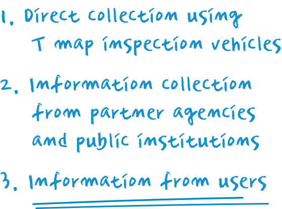
How does Local Contents Team collect location information? The method
is largely divided into three. Firstly, the method consists in collecting
images and information by dispatching inspection vehicles across the
country. This makes it possible to check the road situation and newly
formed changes. If new places came into being, update tasks are
conducted. Secondly, the method is focused on thorough examination
of information received from partner agencies or public institutions.
Immediate data modification is made on detecting some information
of business establishments (stores) that have been closed, moved or
modified. Lastly, it is made by receiving information directly from users.
To sum up, the location information is assembled by making direct or
indirect collection of data and paying attention to information received
from users. The data given by corporations or public institutions can
never be superior to the vivid information given by "the person who is
right on the spot at the very moment" when it comes to changing situation
of the road. The information on the completion date of building, date
of business opening and date of transfer is just one of various clues.
The information from users is the latest one among all. Many collected
clues and information reported from users play an important role
in creating the most reliable location information. T map treats more
than 1,000 pieces of information a day on average. The collected content
goes through a verification process by Internet or phone calls and
its exact coordinate information is identified through the satellite map
before being officially registered. Though it takes time to check every
detail of content one by one, T map never fails to register valuable information
provided by users.

Case of POI modification
We often realize that there are thousands of ways to call the same place. It seems to depend on how each one feels like naming the place. It is because there are copious pieces of information regarding the same place. It is not surprising that the name of a store used by the business owner has nothing to do with the name written on the signboard. Many must have noticed that the name of establishment printed in the credit card bill was different from the one written on the signboard. It is inevitable that the information on places goes through changes of at least a couple of times during the process ranging from the moment in which the information is created to the moment of its final consumption (completion). For examples, using a shortened form of address, mixing the name of road with a lot number, using an old address that has disappeared or has combined, telephone number error, error of Romanization from foreign languages, and spelling error that is a common factor of all mentioned above. This way, data becomes "polluted" and altered, but Local Contents Team is quite used to this phenomenon. We will give you an example.


As we can see in the case above described, being the same place, it can have diverse names since they are collected by way of varied routes. Which name are we supposed to choose then? There is no correct answer to this question though. If you want to get closer to a correct answer, you will have to look for "the name that is called there and now." If one place used to be called "Real Estate Agency Wonseop" is now known as "Wonseop, the Licensed Real Estate Agent," the information of the place must change accordingly. If the place is still written as "Real Estate Agency Wonseop," it is necessary to register the name as a synonym. One thing to remember. It is vital to clarify that multifarious pieces of information, in fact, indicate the same place. Only when we are equipped with a system that groups text information and distance between coordinates through machine learning and determines the grouped data mass as a piece of information, it will be possible to process the variables derived from data. The process may look simple at a glance, but it is challenging to apply this data to all business types present across the country. Our original expertise and technology based on years of study and compilation of data stand out in this system of T map.

* Drawing: Local Contents Team Kewjin Paik


T map Trend Map 2020
관련사이트